Circuit des ponts
 Itinéraire A pied
 Départ : La Roche-Bernard
 Arrivée : La Roche-Bernard

 Departure/Arrival
 Point of interest
Circuit n° 1
- Useful Information :
") Average duration (based on a speed of 4km/hour) 1h45
Average duration (based on a speed of 4km/hour) 1h45 Distance in kilometres 6,5 km
 Point of departure/place of departure La Roche-Bernard
 Point of arrival/place of arrival La Roche-Bernard
 access depuis le parking de la Voûte, à La Roche-Bernard
 Marked trail Jaune

Point 1 - Le port de plaisance de La Roche-Bernard
LA ROCHE BERNARD
LA ROCHE BERNARD

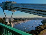
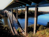
Point 2 - Le pont de La Roche-Bernard
LA ROCHE BERNARD
LA ROCHE BERNARD

Point 3 - Le Moulin de Bourigan
NIVILLAC
NIVILLAC


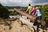
Point 4 - La cité de La Roche-Bernard
LA ROCHE BERNARD
LA ROCHE BERNARD
Download
- PDF_Topoguide RANDO_Fiche n°1_Le Circuit des Ponts_La Roche-Bernard (912.57 Ko)
- Trace GPX_Circuit des ponts_La Roche-Bernard (14.29 Ko)
- PDF_Hiking Topoguide Beautifull escape_File n1_The Bridges Trail (Circuit des Ponts) (8.6 Mo)
- PDF_Wander-Topoführer Schöne Wanderausfluge_Datei Nr1_Brucken Rundweg_Circuit des Ponts (8.63 Mo)