The Brière Land - Terre Brière
 ,
,  ,
,  Itinéraire VTC ou VTT
 Départ : St-André-des-Eaux
 Arrivée : St-André-des-Eaux

 Departure/Arrival
 Point of interest
Circuit n° 1
Circuit n° 2
Circuit n° 3
- Useful Information :
") Average duration (based on a speed of 4km/hour) 3h30
Average duration (based on a speed of 4km/hour) 3h30 Distance in kilometres 13.5 km
 Point of departure/place of departure St-André-des-Eaux
 Point of arrival/place of arrival St-André-des-Eaux
 access Depuis St-André-des-Eaux, suivez les indications vers la Brière puis la Chaussée Neuve.
 Marked trail Jaune

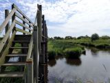
Point 1 - Le port de la Chaussée neuve
ST ANDRE DES EAUX
ST ANDRE DES EAUX

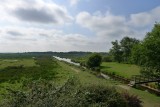
Point 2 - Les chaumières de Brière
ST ANDRE DES EAUX
ST ANDRE DES EAUX

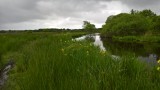
Point 3 - Le port de Tréhé
ST ANDRE DES EAUX
ST ANDRE DES EAUX
Download
- PDF_Topoguide RANDO_Fiche n°20_Terre Brière_St-André-des-Eaux (871.72 Ko)
- Trace GPX_Terre Brière_Saint-André-des-Eaux (11.78 Ko)
- Trace GPX_Terre Brière_Variante hiver_Saint-André-des-Eaux (1.12 Ko)
- Trace GPX_Terre Brière_Tracé de substitution_Saint-André-des-Eaux (7.5 Ko)
- PDF_Hiking Topoguide Beautifull escape_File n20_The Land of Brière (7.48 Mo)
- PDF_Wander-Topoführer Schöne Wanderausfluge_Datei Nr20_Land von Briere (7.49 Mo)