The hillsides - Les coteaux
 ,
,  Itinéraire VTC ou VTT
 Départ : Guérande ou La Turballe
 Arrivée : Guérande ou La Turballe

 Departure/Arrival
 Point of interest
Circuit n° 1
- Useful Information :
") Average duration (based on a speed of 4km/hour) 3h15
Average duration (based on a speed of 4km/hour) 3h15 Distance in kilometres 13 km
 Point of departure/place of departure Guérande ou La Turballe
 Point of arrival/place of arrival Guérande ou La Turballe
 access Autour des remparts, entre la porte Vannetaise et la porte Bizienne
 Marked trail Jaune

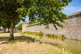
Point 1 - Guérande et ses remparts
GUERANDE
GUERANDE

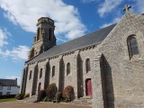
Point 2 - L'église de Trescalan

Point 3 - Les villages paludiers

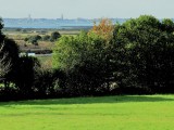
Point 4 - Le coteau
Download